
Personal > Camping > Green River
Kayak Trip:
Labyrinth and Stillwater Canyons
Green River to Confluence, Utah, September 1993
During the summer of 1993, a group of us working at Xerox decided we wanted to take a river trip. We wanted an easy, relaxing trip. We started with a group of ten that were more or less interested. A number of them couldn't make it, and a few dropped out after we started planning. We ended up with three of us taking the trip: Matt Fenn, Maria (then Maria Parino, now Maria Bennett), and myself (Leif Bennett).
After considering a number of rivers, we settled on the lower Green River, in Utah. I'd wanted a trip with slickrock canyons, and none of us wanted a whitewater river. We wanted the trip to take 21 days or so, to fit into Matt's vacation allotment—he was travelling from England and so had the most difficult arrangements. We were all more or less "strong beginner" skill level with our kayaks, and had all done some backpacking. The first few miles are through privately owned land, in Labyrinth Canyon we would be on BLM land, and in Stillwater Canyon we'd be in Canyonlands National Park.
We packed mostly canned and dried food. Since the kayaks would be carrying the weight, we didn't have to stick to lightweight things. We also made sure our gear was in waterproof containers, although the route had no rapids and we didn't expect to get them wet. (In the event, we never capsized or had any trouble, so we don't know if the waterproofing was good enough.) We also picked up a box of trash bags and three large paint buckets with airtight lids for use as toilets, since federal law requires all solid waste to be carried out of the area. For water, we planned to use a Katadyn filter as the primary method, carried enough stove fuel to boil water should that fail, and also carried chemical tablets for emergency use. We also had a collapsible bucket to allow the silt to settle.
Matt arrived on a Saturday, and we went and picked up his rental kayak. We all three had nearly identical boats, plastic sea kayaks with an Aleutian bow (Aquaterra Chinook). Maria and I had done the bulk of the shopping beforehand, but we had a few more things to pick up. Matt ended up taking a 24-pack of Coca-Cola, and a nonstick frying pan; we chose a few nice things to eat that we could pack, and got our things ready. That evening we packed the car and loaded the kayaks on top, and slept.
It took us two days to drive from Los Angeles to Moab, where we would park the car. At Moab, we checked in with Tex's Riverways and found our motel for the night.
Crystal Geyser
We put in for the trip at Crystal Geyser, about 115 miles above the confluence with the Colorado. The geyser is a cold water geyser, powered by carbon dioxide deposits. It is irregular, averaging about 14 hours between eruptions.
When we get there, a few people are waiting around. One of them tells us they'd watched the tail end of the geyser's eruption the previous day, and that it had been 14 or 15 hours since then. We think it would be nice to see the geyser, so we don't rush when unloading the boats and packing them. Matt gets out the first of his Coke cans, and notes that they are quite warm. He decides it would be fun to cool it down in the geyser's pool, which is cooler than the river. First he checks to see if the can will float in one of the little pools off to the side, and it does. Then he drops it into the main pool, where it promptly sinks down out of sight. The main pool had a few bubbles trickling up it at all times, and I believe the extra CO2 in the water decreased the density just enough so that the can sank.
About half an hour later, the geyser starts to erupt. It is pretty spectactular, especially as this is such an incongruous sight in the middle of a non-volcanic area. We watch, and Matt takes advantage of the spout to cool off. After the eruption is over, we found Matt's Coke can lying slightly battered on the travertine surrounding the main pool.


First Days
After the eruption, we launch the kayaks and paddle lazily for a few hours, stopping on a sandbar. The planned time on the river was a nice, lazy 15 days. People who move right along can do it in 7 days; we took a few days for exploring from our campsite, but even so we weren't pushing ourselves at all. The first night we pitch camp on a sandbar near some farms; that was the only night we put up our tents. The weather was so nice and there were so few bugs, we just threw down a foam mattress and sleeping bag for the other nights.


Trin Alcove
Our first layover day (where we camped two days in a row in the same spot) is at Trin Alcove, mile 90. We hike up into Three Canyon a little ways in the morning, enjoying the walls and the solitude. We consider packing up and moving down the river in the afternoon, but it just doesn't seem worth the trouble. Instead, we have a lazy afternoon. I try out an idea I'd had, to see if the Katadyn filter could be gravity-fed. I'd replaced the usual 2-meter intake hose with about 7 meters of rubber tubing, and I suspend a bucket from a tree and let the filter sit at ground level over a cooking pot. It works slowly, but we aren't in a rush.
A group of people on jet skis passes us this day. They were towing their supplies on innertubes, and were a good deal noisier than anything else we encounter on the trip.


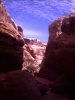
Bowknot Bend
A few days further on is Bowknot Bend, miles 70 to 63. It's a place where about 10 kilometers of river makes a loop and returns to within half a kilometer of where it started. We stop just before the bend at Spring Canyon Point, about mile 71, on a nice beach. That morning, while we are preparing to make breakfast, we watch a coyote dancing at the edge of the river about 200 meters downstream.
Then we get into our kayaks, and land about a mile downstream on the other side of the river, at the upstream side of the narrowest portion of Bowknot Bend. We hike partway up the partitioning fin of rock, and get a bit of a view. We can't find a spot where we can see both sides, though.


Horseshoe Canyon
That night, we stop at Horseshoe Canyon, mile 59½. We have another layover day, in which we hike up the canyon to the rim. It is a nice hike, with a little tamarisk forest at the beginning and a good climb up and out. Another party of boaters passes us this day: we watch them pass our sandbar from halfway up the canyon walls.
We spend the next night at Point Bottom, mile 49 or so.


Upheaval Dome
Another of the layover days is at Upheaval Bottom, mile 44. Upheaval Dome is a fascinating formation formed when a bubble of salt pushed upwards, folding the rock into a dome. Erosion has worn away the upper part, leaving concentric layers, and forming a ring-shaped canyon where a softer layer has eroded faster than the rest. We walk up the wash that morning and explore. We encounter some jackrabbits in the cool of the morning.


Fort Bottom
Fort Bottom (mile 40) has an old masonry tower on the ridge, and a cabin below it. We stop there to eat lunch and check out the ruins.


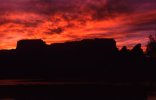
Beaver Bottom
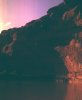
We continue on to Beaver Bottom, mile 35, where we have a nice evening. The full moon rises (of course) right after sunset, and I have to try a picture. The sunrise is lovely the next morning.
We start off that morning and run down past some riffles at Queen Anne Bottom (mile 33½). Maria and I are glad we'd taken the surf kayak class, but Matt does fine without it. It's the closest we come to finding rapids on the trip; they'd barely count as class 2. We pick a nice little side drainage for a lunch stop; it isn't very accessible, but we are hungry. There are a few nice plunge pools, which are always fun to look at.


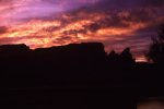
Valentine Bottom
We stop for the night at Valentine Bottom, mile 28 or so, where we're treated to a spectacular sunset. We worry a little about the weather, but not enough to pitch the tents. Instead, we sleep with a tarp next to our sleeping bags, with the intention that we'll pull it over us if it starts to rain.
We have a dry night.


As we float leisurely down the river that morning, I spot a large white bird working the shore. It stays there long enough for me to get the camera out, and then flies away.


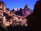
Turk's Head
We stop for the night at Deadhorse Canyon, mile 19½, overlooking Turk's Head. I have plans for the morning, since it looks like it'll be another beautiful one, so I convince Maria to sleep on a ledge above the canyon. Matt doesn't want to, so he beds down on the beach across the river.
That morning, I ask Maria to marry me, and she says "you bet!"


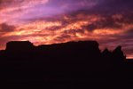
Confluence Overlook
The day before we reach the confluence, we stop for the night at mile 1. I convince the other two that we should take our sleeping bags and climb up to the rim for the night. We secure the boats thoroughly, and climb up the side canyon. We have a great view of the Maze region of Canyonlands National Park, from a place that's not too easy to get to by car. We sleep in some of the potholes. That night, we are gently awakened by a slight rustling and scratching noise, which turns out to be a mouse that had found one of our belt pouches containing a nut/cereal/chocolate trail mix. We watch the mouse for a little while, as he nibbles his way through the plastic bag and takes a few Cheerios. Then we secure the food in a more sturdy container.
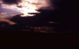
Sunrise is spectacular, with some clouds and great color. After watching things, looking around a bit, and other distractions, we climb back down to the boats. We pack slowly and explore a bit, then paddle the mile to the confluence. We beach at a sand bench on the east bank of the Colorado. The pickup is scheduled to come the next day, so we wander around a bit and explore. That night we have a little bit of rain, more of a sprinkle. The clouds had looked a little threatening, so we'd put out a tarp at the foot of our sleeping bags; when we noticed the rain, we pulled up the tarp to cover the bags and went back to sleep.


Tex's jet boat arrives the next morning. It is a bit startling to be on such a noisy craft after two weeks of kayaking. The boat is their regular Colorado River tour, and we are in a crowd of more than (gasp) ten people. In short order the boat winds its way up past the goosenecks and Dead Horse Point, with pretty much the same sort of canyons and beaches we'd seen on the trip down the Green.
Red Canyon
On the drive back, we went through Red Canyon, very close to Bryce Canyon National Park. We stopped for a bit of lunch.


It was a very good trip. I'd do it again, and probably will once the children are old enough. With a young child, we'd have to take a canoe or tandem kayak. This was my second trip with Tex's Riverways (the first was in 1969 or 1970), and I'd be happy to go with them a third time.
Copyright © 1993, 2001, 2006, Leif Bennett. All rights reserved.